
FiSci's Fiery Precision: How a Drive Down the Stuart Highway (and Google Street View!) Reveals Unprecedented Fire Scar Accuracy
Bushfires are a powerful, natural force, shaping landscapes across Australia. Managing their impact, especially through proactive mitigation burns, is a critical task. But how do we accurately assess the extent and effectiveness of these burns, particularly in remote areas? At FiSci, we're leveraging cutting-edge deep learning to provide answers, and we've found an unexpectedly powerful ally in a tool many of us use every day: Google Street View.
Join us on a journey to the Northern Territory, where a recent early dry season burn along the iconic Stuart Highway became a perfect case study for our technology, revealing insights with remarkable clarity.
Setting the Scene: The Vastness of the Territory and Hidden Risks
The Australian outback is a landscape of immense scale. Our focus takes us to a stretch of the Stuart Highway in the Northern Territory.

Caption: Our area of interest along the Stuart Highway in Australia's Northern Territory.
To understand the importance of mitigation burns, we first take a virtual trip back in time. This Google Street View image from December 2014 along the same highway shows dense grass fuel loads. These conditions highlight the potential for intense, widespread fires if left unmanaged.
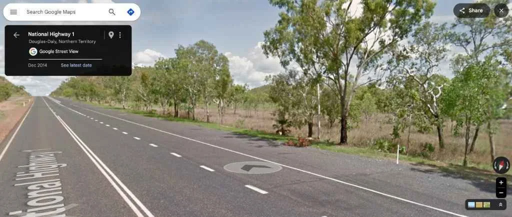
Caption: Google Street View, December 2014: Dense grass fuel alongside the Stuart Highway, illustrating the need for mitigation efforts.
FiSci's Innovation: A New Eye in the Sky
Fast forward to a recent early dry season, and a strategic mitigation burn has been conducted. This is where FiSci's advanced deep learning algorithm comes into play. Trained to analyze satellite imagery with incredible acuity, it can detect and map fire scars with a new level of detail.
The image below shows the output from our algorithm for the area. The red overlay pinpoints the extent of the recent burn.

Caption: The burn scar (shown in red) as detected by FiSci's deep learning algorithm, overlaid on satellite imagery.
The "Aha!" Moment: Ground-Truthing with a Digital Drive-By
Satellite data is powerful, but how can we be absolutely sure of its accuracy on the ground, especially with such intricate details? Traditionally, this involves costly and time-consuming field visits.
But we had an idea: What if we could use Google Street View's archives to visually correlate our algorithm's findings? It’s like having thousands of geo-located, time-stamped photos at our fingertips.
Proof in Pixels: The Highway as a Firebreak
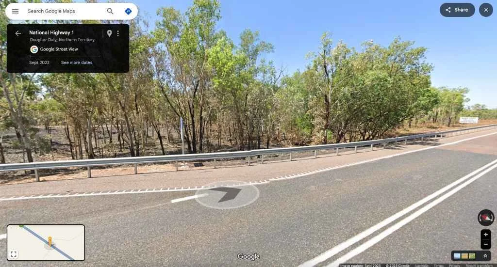
Our algorithm indicated the fire scar running right up to the northern edge of the Stuart Highway, suggesting the road acted as an effective firebreak.
A quick virtual drive to the exact coordinates in Google Street View, captured in September 2023 (post-burn), provided striking confirmation. Look to the right (north) of the road – clearly burnt. To the left (south) – unburnt.

Caption: Google Street View, September 2023: The Stuart Highway acting as a firebreak. The landscape to the right (north) is clearly burnt, while the left (south) remains untouched, perfectly matching our algorithm's detection.
This is a fantastic visual testament to both the fire's behaviour and our algorithm's ability to map its boundaries precisely.
Down to the Detail: The Power of 10-Meter Resolution
The story gets even more compelling when we zoom in. FiSci's algorithm operates at a 10-meter resolution, meaning it can identify relatively small features and nuances in the landscape.
Notice the distinct clump of trees in the satellite image below, right at the edge of the detected fire scar. Our algorithm shows the fire stopping precisely at these trees.

Caption: FiSci's algorithm (red overlay) shows the fire scar boundary precisely meeting a clump of trees (center) along the Stuart Highway.
Could this level of detail be real? Once again, Google Street View provided the answer. The image below, taken from the highway looking towards that exact clump of trees in September 2023, shows the fire did indeed halt right where our algorithm indicated.
Caption: Google Street View, September 2023: On-the-ground proof! The fire stopped exactly at this clump of trees, showcasing the 10-meter precision of FiSci's detection.
This remarkable correlation between our high-resolution satellite analysis and readily available Street View imagery underscores the power and accuracy of our deep learning models. It's this fine-scale understanding that can make all the difference in planning and assessing fire management strategies.
Beyond Detection: Understanding Fire's Nuances
This innovative combination of FiSci's deep learning algorithm and Google Street View validation doesn't just tell us where a fire has burned; it helps us understand the nuances of its behavior. We can see how landscape features like roads and even small stands of vegetation influence fire spread. This provides invaluable feedback for land managers, helping to refine mitigation strategies and improve ecological understanding.
The Future is Clearer with FiSci
At FiSci, we're committed to pushing the boundaries of what's possible in environmental monitoring. This novel approach of using Google Street View to validate and enrich our AI-driven fire scar detection is just one example of how we're bringing greater clarity and insight to complex environmental challenges.
By providing more accurate, timely, and detailed information, we empower better decisions for land management, biodiversity conservation, and community safety. The view from space is powerful, but when combined with a perspective from the ground – even a virtual one – it becomes truly transformative.