
Mount Nelson Prescribed Burn Analysis
The Mount Nelson area of Tasmania presents a considerable bushfire risk due to steep, hilly terrain and high, uninterrupted fuel loads bordering an urban area. The project area contains high-value community assets, including Hobart College and the surrounding Mount Nelson residential community.
Demonstrating Mitigate’s Strategic Planning
In this case study, we take a planned prescribed burn and use it as an exercise to show its effectiveness, demonstrating Mitigate's capabilities in strategic planning. This simulated analysis shows how the Mitigate platform informs prescribed burning to protect urban fringes and critical community assets in high-risk, steep terrain.
FiSci's initial analysis confirmed the extreme exposure:
The main vegetation communities are Eucalyptus variations, and fuel loads exceed 20 t/ha in high-risk areas.
Under extreme weather conditions, the average uncontrolled fire size across the project area is estimated at approximately 130 hectares.
The uninterrupted high fuel load significantly increases the ability for a large, uncontrollable fire.
Area Analysis
The Mitigate tool visualizes the Mount Nelson area which is steep, hilly and heavily forested terrain. There have been a number of historical fires here, with hazard reduction activity present however there are areas of high fuel loads still present.

Undulating terrain causing increased uphill fire activity.

Urban area to the East with the main vegetation communities being Eucalyptus variations

Hazard reduction in the South and West in the project area and also near the the Mount Nelson Theatre, however these were performed a number of years ago (2016 - 2021).
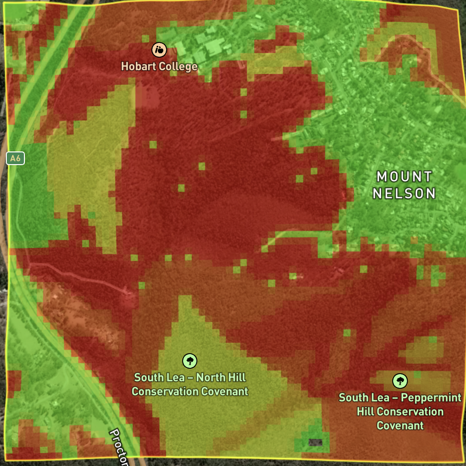
Fuel loads in excess of 20t/ha
The Prescribed Burn
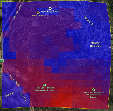
Fuel Load Post-Burn
Following the treatment, simulations under the same extreme weather conditions estimate a 40% reduction in the average fire size across the project area. This significantly increases protection for property and urban areas from bushfires approaching from the northwest and southeast.
Fuel Load Pre-Burn
The risk of a large fire is high due to uninterrupted heavy fuel loads. Based on hundreds of simulations under extreme weather, the average uncontrolled fire size in this area is estimated to be approximately 130 hectares over an 8-hour period.


A prescribed burn is scheduled for 2025 (date TBC) in an area that FiSci Mitigate estimates has very high fuel loads. The burn's boundaries are defined by a trail to the north and previous fire boundaries to the west and south.

What If Scenario #1
Extreme fire day with the wind coming from a NNW direction.
Post-treatment, the significantly reduced fuel load greatly lowers the risk to Hobart College and the community to the east.
Pre-treatment, the high fuel load in the North and West poses a significant risk, where any ignition could lead to a large, uncontrollable fire.


What If Scenario #2
Extreme fire day with the wind coming from a SE direction.
Post treatment a south easterly wind, common in the summer, poses less risk to Hobart College and the community to the east due to lowering of the fuel load to the south.
In the summer there is a risk from the South and East that if there is an ignition in those locations (in red) a large fire will occur.

What Would We Suggest Next?
Insights into how we’d further treat this project area based on what If scenario #2.
The ultimate outcome that we are trying to achieve with this strategy is to protect Hobart College from a fire starting in the South of the project area.
After treatment, the same analysis demonstrates this risk is significantly reduced, with potential fires being smaller, spreading slower, and providing a much larger and safer window for reaction.
Before treatment, the inspection tool shows Hobart College is highly exposed to large, fast-spreading fires from the south, leaving minimal time for response under extreme weather conditions.


Based on the fire simulation model projections after the treatment is applied, FiSci recommends implementing an additional treatment to the west in 2026 to establish a low-fuel-load barrier between the high fuel loads to the south and the college.
After treatment, the risk has been significantly reduced, with the largest fires now being deflected around the college due to a lower fuel load, as shown in this 8-hour fire spread model. Additionally, the reduced fuel load along the southern edge of the campus slows fire spread, providing more time for evacuation and defensive measures.

